Home | Information
Comparison of the three editions
The biggest difference between the three edition is in the number of charts and that they contain progressively more and fainter stars and deepsky objects. The density of objects is much higher in the 20-chart and 30-chart editions. The limiting mangitude for the labels is not absolute, but instead vary depending on how crowded it gets. That means that there are fewer labels in comparison to deepsky objects in the most dense regions, such as the Virgo cluster and the Milkyway. I've tried reducing the number of labels even further from what Cartes du Ciel generates to make these regions more easy to navigate. I've spent countless hours manually inspecting and moved around labels on all charts and adding common names where suitable. I do appologize if any errors have crept in.
All editions also have two index pages of the northern and southern hemispheres with the chart numbers clearly visible. On each chart there is also a navigation help at the top right to help you navigate to the correct chart wheather it's up, down, left or right. Whenever possible I've made it so that (for northern observers) if you want to see the sky to the right of the current chart, you just have to flip to the next page, and to go left you go back one page.
10 charts Small-scale Atlas
The 10-chart edition is a general overview atlas, perfect for having close by at the telescope, to find inspiration on where to go next, or for showing someone the night sky. It's a good beginner's atlas, a step up from simple planispheres and one/few-page atlases, and includes all the Messier objects and a bunch more. It doesn't really require the index charts, all it usually takes is one or two page flips to end up where you want to be. When printed at a professional printing service as a saddle stitched brochure without inside margins it makes for a really nice atlas with very large but detailed charts.
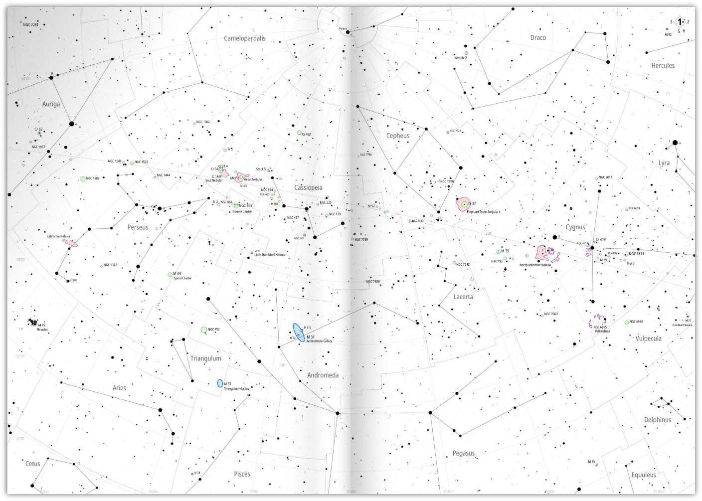
A sample page-spread, as it would appear if printed without margins and overlap, which is possible to do with this atlas. Click image to enlarge.
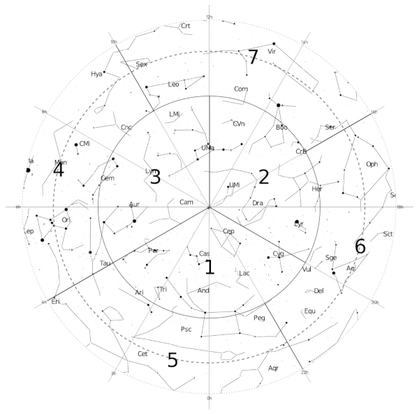
Index chart of the northern hemisphere.
Click to enlarge.
10 charts (double-page spreads) of the whole sky (both hemispheres).
Each chart 109° x 74° (for A4 w/o inside overlap)
Stars down to magnitude 8.
Deepsky objects to magnitude 8.5.
Labels to varying magnitude.
Download A4 version (no inside overlap)
(File sizes: ~3 Mb)
20 charts Medium-scale Atlas
The 20-chart edition is what got me started in creating these atlases. The combination of its medium-scale and wealth of deep sky objects make it suitable for being used at the desk or when navigating around looking for interesting objects to observe. The views are detailed but don't get so narrow that you can't see what else is close by.
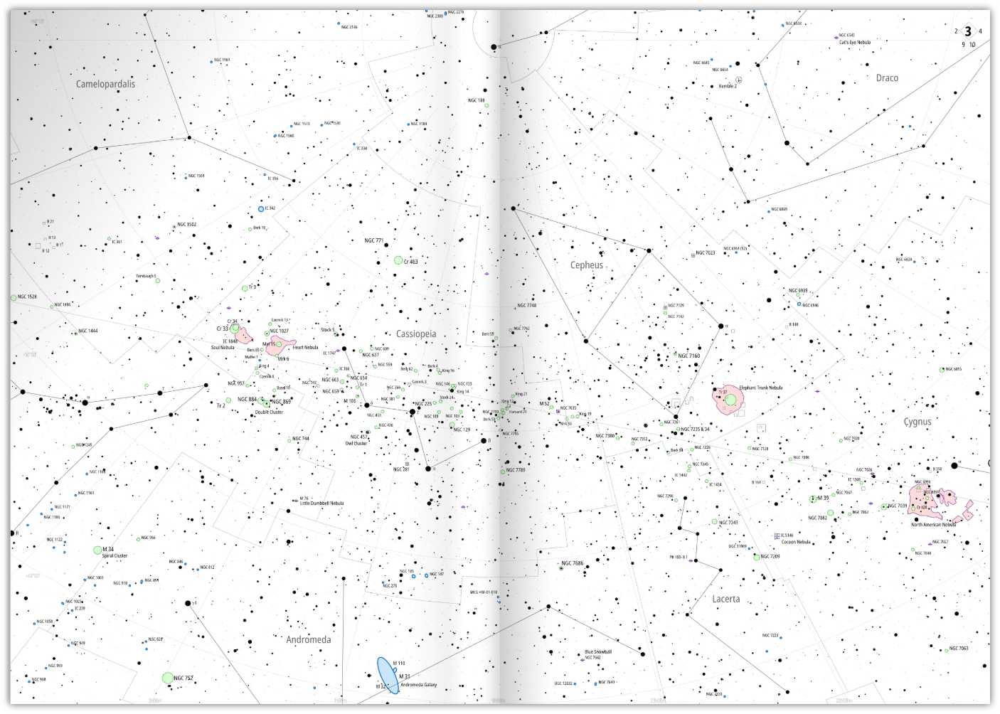
A sample page-spread, as it would appear if printed without margins and overlap, which is possible to do with this atlas. Click image to enlarge.
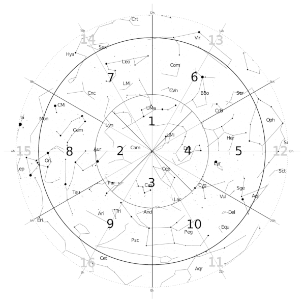
Index chart of the northern hemisphere.
Click to enlarge.
20 charts (double-page spreads) of the whole sky (both hemispheres).
Each chart 67° x 51°
Stars down to magnitude 9.
Deepsky objects to magnitude 12.5.
Labels to varying magnitude.
Download A4 version (no inside overlap)
(File sizes: ~5 Mb)
30 charts Large-scale Atlas
The 30-chart atlas is the most detailed of the three editions, and has a few more objects than the 20-chart editions, and with its more narrow field of view it gets perhaps slightly less crowded. This one is probably the most suited for being used at the telescope given the larger scale.
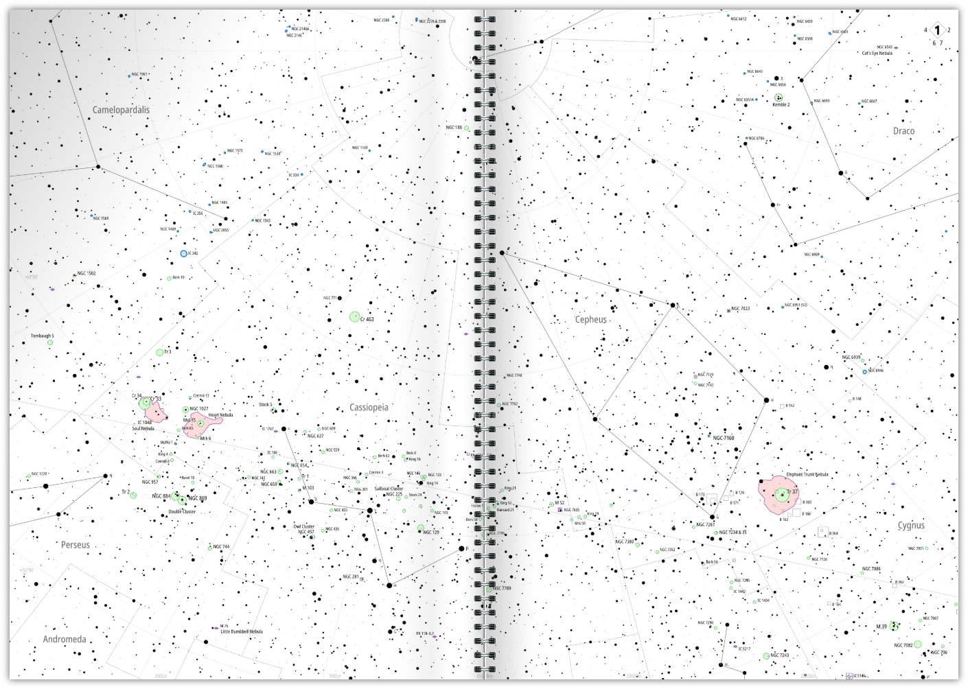
A sample page-spread, as it would appear if it was printed and spiral bound. The real PDF has a small 7 mm (0.3") overlap between the left and right chart, which is missing from this sample image. So no part of the sky is lost behind the binding. Click image to enlarge.
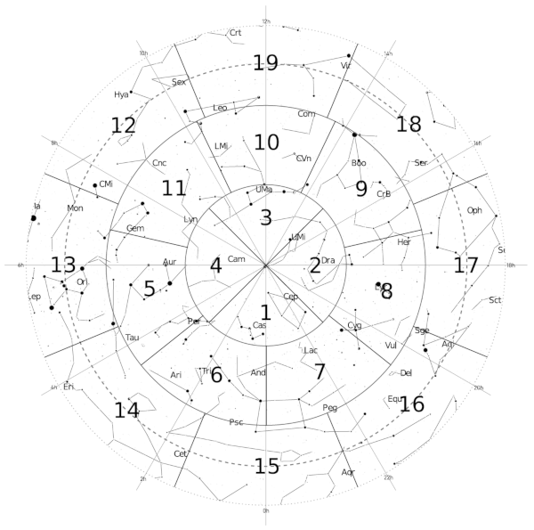
Index chart of the northern hemisphere.
Click to enlarge.
30 charts (double-page spreads) of the whole sky (both hemispheres).
Each chart 52.5° x 40°
Stars down to magnitude 9.3.
Deepsky objects to magnitude 13.
Labels to varying magnitude.
Background
An amateur astronomer myself, I had been looking around for a general purpose overview sky atlas for a long time. Not necessarily an atlas to be used at the eyepiece (I already had that), but something that could be lying around on my desk, and be my goto atlas when looking up a constellation, or planning what part of the sky to visit next, or just to remember places already visited. To be that first map you look at when seeing what constellations are visible tonight and you have to decide where to go first.
I found most sky atlases to be either too small physically, have too many distractions in the form of huge star symbols, thick grid lines that steal attention, too many labels, repeated chart legends etc. Many require lots of flipping through pages, partly because of (for me unnecessarily) large margins resulting in wasted paper real estate. The closest I came to finding a perfect star atlas was the Wil Tirion Sky Atlas 2000.0 but it's printed on unwieldy large sheets which I found makes it difficult to easily carry with you, or fold in any kind of way. Also it has no constellation lines.
For an atlas primarily used in the dark, having large labels and big star symbols make sense, but I wanted something that would perhaps be less useful for locating individual objects but on the other hand more useful for seeing where each object is located in relation to all the other objects, or in relation to the current constellation, or the constellation nearby. So when you're looking at one constellation and wander off to some deepsky object out at the constellation boundary you can still see where that object is in relation to the next constellation.
To accomplish that I realized I ought to utilize double page spreads. An A4/Letter sized atlas that can’t be spread out really makes no sense to me. When you spread it out to form large A3 charts you suddenly have twice the map area, without being physically bigger when folded. It also makes the atlas easy to print, and makes it transportable and easy to hold in your hands in any way you like. The margins have to be small though so you would view one spread as one whole chart and not be distracted by the binding.
Having started working on the atlas, a few compromises I did was to include fewer stars than perhaps normal, and in general made them smaller. I also made the grid lines less intrusive and instead emphasized the constellation lines and the constellation boundaries. I do realize that smaller labels makes it harder for older eyes to read the labels and a bit harder in the dark for everyone, but the benefits are that you can squeeze more information in there before it gets too cluttered, and I felt I really wanted some empty space there as well to make it easier to orient yourself. Besides, my primary intended use for the atlas was at the desk, although now I use it at the telescope as well.
My work actually started with the 20-chart Atlas, which seemed to yield just the perfect scale for me. But while I was working on it I figured I ought to use the opportunity to also create a smaller-scale version as well as a larger-scale version. In the end, I think they each serve their own special purpose. And I hope that by making them available for download they can be of some use to others as well.
Here is a thread on Cloudynights where the atlas is discussed.
Printing instructions
A4 / Letter format
Each of the three atlases come in one version for A4, and one version for the Letter format. Both versions actually utilize the whole sheet of paper, but the A4 charts gets a little extra vertical overlap, and the Letter charts a little extra horizontal overlap. The scale is otherwise the same between the two. Just download the version matching your printer and print the whole document like a booklet.
Colors / BW
The atlases only come in colored versions. If you prefer black-and-white just print them as such. It's not always optimal but adding black-and-white versions would have added 8 more versions to an already large number of files. The colors have been chosen to be red-light friendly though so it should be possible to print the atlases in color if you want to and still be able to see everything in the dark.
Margins
I've left the margins in the PDF files to 0. That means you must take care to specify any additional margins you want when printing. Most desktop printers won't print to the very edge, so also remember to specify "Fit to page" when printing, and not "Actual size", or there will be a thin part that gets lost at the edges of the pages. Also, this automatically adds a thin printer-dependent minimum margin that there is no way to get around, unless you send the PDF to a professional printing service.
Chart overlap
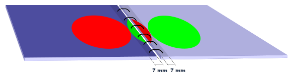
All atlases come with a default "inside" overlap between the left and right page of 7mm (1/4”), and the 10- and 20-chart A4 versions also come with no overlap at all. Whether the overlap is desirable depends on the printing situation and personal preference, and as with most things it's a compromise. It could be argued that it should have been larger, but 7mm was based on the fact that that's about how far from the margin a normal spiral binding coil on a not too thick stack of papers reaches. This allows printing over the whole physical page and having the overlap fall behind the spiral binding coil and being visible through it. The printer most likely adds a few millimeters (mine adds 5 mm) of margin to this as well.
However, if your binding method requires more than 7 mm + whatever minimum margin your printer can print to, then you have no choice but to introduce a little extra margin on the inside (and top and bottom). If people feel that 7 mm + printer margin is too little it is possible for me to create a new version, but it would take that extra overlap on expense from the "outer" overlap *between* charts. And also, too much overlap kind of defeats one of the purposes I had with the atlas, which was to provide a sense of looking at one big chart when folding it out, and that's why I settled for a minimal 7 mm.
On the other hand, if you intend to print something like a saddle stitched brochure which has no inside margin allowing the graphics to extend all the way to the stiching, most effectively creating one big double-page chart, then use the A4 versions without any inside overlap. Unfortunately this version doesn't exist for the Letter version, but could be produced if there is enough interest (let me know).
About the author
 My name is Olle
Eriksson, a 40 year old amateur astronomer and software developer, living in the south of Sweden. I've
been interested in astronomy for a long time, but I had a long break from astronomy until I decided to
take it up again in recent years. My interest in astronomy started at the age of 15 when I found a book
at the library about building your own telescope. I knew I was interested in astronomy but wasn't sure
how I could delve into the subject. And that book turned out to be what opened the door for me. I
figured that if I could build a telescope that would surely open up the world of astronomy for me in
some way. From there I built and re-built an 8" telescope several times, and started using it on clear
nights to explore the night sky. I remember the first time I saw the Andromeda galaxy and ran inside to
tell me father about it, who would then come out and watch it together with me. Or Jupiter's moons, or
Saturn's rings.
My name is Olle
Eriksson, a 40 year old amateur astronomer and software developer, living in the south of Sweden. I've
been interested in astronomy for a long time, but I had a long break from astronomy until I decided to
take it up again in recent years. My interest in astronomy started at the age of 15 when I found a book
at the library about building your own telescope. I knew I was interested in astronomy but wasn't sure
how I could delve into the subject. And that book turned out to be what opened the door for me. I
figured that if I could build a telescope that would surely open up the world of astronomy for me in
some way. From there I built and re-built an 8" telescope several times, and started using it on clear
nights to explore the night sky. I remember the first time I saw the Andromeda galaxy and ran inside to
tell me father about it, who would then come out and watch it together with me. Or Jupiter's moons, or
Saturn's rings.
Very soon I realized that the heavens was a very magical place that strangely enough few people knew anything about. I would see things out there that my friends and family had never seen, and I started to immensely enjoy navigating my ways among the stars. Till this day I can't really wrap my head around the fact that the stars are right there all around us, even during the days, but we don't think about them because we're so focused on our normal earthly daily routines, or perhaps don't even see them because of the light pollution in cities.
Maybe that's why I have always enjoyed using planetarium software on the computer. They provide a way to access the night sky from the comfort of your desk, or when the skies are cloudy. But for me, nothing beats an old-fashioned physical star atlas when it comes to providing a real sense of exploration as you navigate the heavens just using a piece of paper in your hand.
Contact
Any questions or comments, or if you find errors in the charts, let me know at mail@olle-eriksson.com.